JOHNSON
BURIALS OF LONG AGO
Two miles E.S.E of
Keith A. Gohl, of
|
LAST |
FIRST |
DIED |
AGED |
COMMENTS |
|
Johnson |
John |
09/05/1855 |
40-6-7 |
b: 11/29/1814 per R.J.D. calculator |
|
Johnson |
Sarah [Mrs.] |
11/01/1872 |
51-11-16 |
b: 11/16/1820 per R.J.D. calculator |
Comments by R.B.Whitsett:
This would indicate that John was b. ca the close of the war of 1812 or about Feb. 28, 1815; and that his widow Sarah was b. on or abt. 15 Nov. 1820.
This huge 10-sided block of
carved stone in the creek was abt. 150
Extensive research in the Cass County Courts failed to disclose traces of any pioneer settler or land-owner named “John Johnson” in this immediate area but does reveal an Israel Johnson a prominent pioneer-settler who may have been a close relative of John’s.
Israel Johnson was born 1803 in southwestern, PA; Settled for a time in or near Richmond, IN before coming to Cass Co. bef.,1829; Entered farm or tracts of land in Section 9 of Washington Twp., per old manuscripts & patented in 1846 [abt. 9 yrs. before the death of John Johnson.] For information on Israel Johnson, see Helm’s “History of Cass Co., IN”, 1886 pg. 520.
No other grave markers were found during nearly an hour’s search of this area & no record nor recollection of any pioneer family burial ground in this immediate vicinity is known of by the present reporter who is the chairman of the L’Anguille Valley Historical Associations Pioneer Cemetery Committee & local member of the Indiana Historical Society’s Committee.]
Although site-indications suggest that the stone may once have stood on the brink of the interurban right-of-way [rough ground & rusted fragments of a wire fence were noted there]: and may have been knocked down the west incline into the creek by a falling tree;[the decaying log of which added greatly to our difficulties in excavating the monument from the creek-bed]; the present writer doubts that so seemingly very old [and apparently very large tombstone would have been erected on what seems to be a man-made elevation of the present century,--unless the tombstone was deliberately move and re-erected there by interurban construction crews.
The question therefore arises, “Might not this huge section of an old monument been transported to this area from some distant point; perhaps by interurban flat-car, gondola or even by a modern truck or wagon & dumped down the incline [with perhaps other rock or “fill”], for the purpose of erosion control of the former interurban roadbed?
Investigation disclosed
evidence that this has occurred at least once in this area decades ago on the
orders of the late Charles Tabor who owned land in this woods & who also
owned a lot on
The
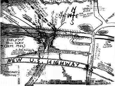
location of the Johnson tombstone was very difficult to describe; due to several
faulty & contradictory old maps, and to the confusion of the boundary-lines
in this area [of numerous winding small creeks, irregular terrain, steam &
electric railroad expansions & recessions; abandoned roads, radically
re-routed highways [winding, angling, curved & irregular shaped farms &
Indian reserves] which evidently were surveyed before the orthodox
crisscrossing of the area with the congressional-township surveys were started
and which do not conform at all to the letters, lines, boundaries & corners!
Even the 1939 Aerial photographs of the area are inadequate & misleading;
for the radical re-routing of Hwy.35 [
Report submitted on October 3, 1952 by Robert B. Whitsett, Chariman of the
L’Anguille Valley Historical Society
for the
![]()
![]()
Report was input by Pat Fiscel March 2007 for the Cass County INGenWeb Project.